WGI Icon_Green (1)
WGI Projects
Project Experience

Learn more about successful projects from some of our clients.

Plan Your Next Project!

Kick-start your next project with this quick step-by-step intake form.
About
WGI

WGI is a national design firm creatively transforming infrastructure and real estate through tech-driven services.

Our
Locations

You’ve seen our award-winning team, proven expertise, and industry authority. Now let’s make your next project a success.

Meet Our
Leadership Team

Our Executive Leadership Team and Practice Area Leaders bring decades of experience and client successes to your next project.

Our Practice Area Leadership

Our nationwide team of engineers, surveyors, planners, and architects offers
market-leading experience.

Firm Registrations

WGI holds nationwide registrations to perform engineering, surveying, architecture, and environmental science services.
WGI
Insights Blog

Our blog covers client interests like infrastructure, real estate, regulations, and smart, connected communities.

Whitepapers & Publications

Our whitepapers highlight our design experts' innovative insights and best practices for the AEC industry.

News &
Press Releases

Dedicated to your success, we invite you to subscribe to our newsletter for the latest news, case studies, and insights.

WGI
Media Room

Our passionate design professionals frequently share their expertise at webinars and virtual events.

Expertise for Resilient, Connected Infrastructure

Creatively transforming how our world is envisioned, designed, and experienced.

Accelerating Infrastructure

At WGI, we creatively transform how our world is envisioned, designed, and experienced. Our expert team of professional engineers, registered land surveyors, and design professionals are ready to make your next project more successful together.

HP-card-1
Serving communities for the long term.

The most effective public projects balance technical requirements with the everyday needs of the communities they serve.

LA_Gulf-Coast-Town-Center-13172665-1536x1152
Business goals drive every decision.

Private-sector projects need integrated teams that understand the connection between site constraints and business outcomes.

Server Room Img 3 (1)
Built for continuity from day one.

Data, energy, and critical environments move forward with the coordination needed to reduce risk and maintain operations.

250 +
Continuing Contracts

WGI’s active master contracts across the country reflect long-term agency relationships and dependable project support.

200 +
Licensed Professionals

Specialized multidisciplinary expertise gives every project the technical depth needed for informed decisions.

22,000 +
Project Successfully Completed

Proven work across markets and locations gives WGI the experience to guide complex projects with confidence. 

Connected Disciplines for Stronger Outcomes

Work with one integrated partner to simplify coordination across complex infrastructure projects, bringing specialized expertise together to reduce handoffs, align decisions, and support smoother delivery from planning through completion.

From high-rise design to SCADA systems for water treatment facilities, WGI's Structural Engineers, Architects, and Restoration Professionals have the experience needed to move your next project forward.

Connected transportation planning and design allow WGI to help clients improve mobility, manage growth, and support safer travel.

WGI’s engineering turns site constraints into coordinated design decisions that enable projects to work as intended.

Better project decisions start with accurate geospatial data that reveals existing conditions and what may affect delivery.

Transportation

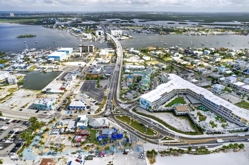
SR 865 (San Carlos Blvd)

See how WGI assisted in the overhaul of SR 865 (San Carlos Boulevard), the primary gateway to Fort Myers Beach, carrying thousands of residents and visitors daily across the Matanzas Pass and Hurricane Bay bridges.
SR 865 (San Carlos Blvd)
Turning Data into Informed Decisions

Digital Insights Integrated with Every Phase

Better project decisions start with data teams can trust, from WGI’s innovative field capture and GIS analysis to modeling and visualization.

GIS Analytics

LiDAR, drone data, and field capture tools give teams accurate existing-condition insight before design decisions advance.

Real-Time Visualization

Interactive visualization provides a more practical way to see what’s below and understand what each decision may mean in the field.

Digital Delivery

Connected workflows keep project information aligned across teams, helping reduce rework and support decisions with full context.

A National Network of WGI Offices

Strategic locations across the U.S. connect clients to multidisciplinary teams positioned around their markets and industries.

25 Locations

What Clients Say About Working with WGI

News & Insights

Stay up to date with all things WGI by accessing our Blogs, Publications, news releases, Whitepapers, and more!

What Could Your Project Achieve?

Let WGI help you define delivery steps, align the right expertise, and build momentum toward long-term success.

2.2.1 Geospatial & Land Surveying (8)
02194342_00_N76
5005_N31