.png?width=185&height=175&name=WGI%20Icon_Green%20(1).png)



















WGI's survey crew completed a bathymetric survey of the lower Withlacoochee River to collect data that will be incorporated into the Withlacoochee River Watershed Digital Elevation Model (DEM).
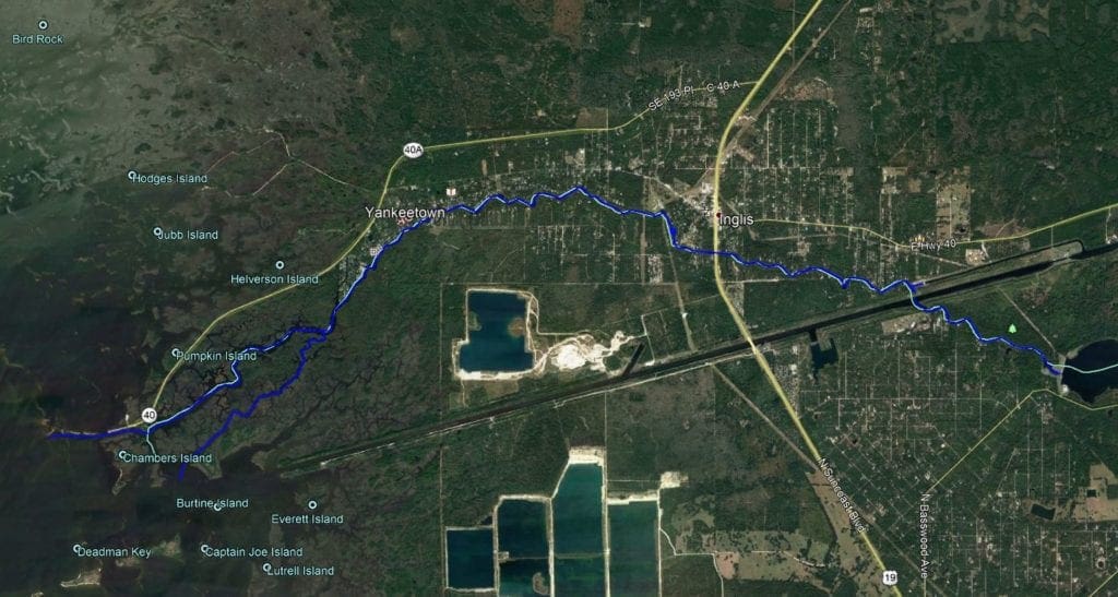 The project limits were from the Inglis Bypass Spillway to the mouth of the river at the Gulf of Mexico which included several surrounding tributaries.
 In total, the project length was approximately 14 miles. The multi-beam data collected along the river is to be used to improve the hydrodynamic modeling of the lower region of the river.
The data collected will be used to create a model and will help to establish minimum flows for the Lower Withlacoochee River. The model will help to protect the river from withdrawals and will help maintain the area's natural beauty.
In total, the project length was approximately 14 miles. The multi-beam data collected along the river is to be used to improve the hydrodynamic modeling of the lower region of the river.
The data collected will be used to create a model and will help to establish minimum flows for the Lower Withlacoochee River. The model will help to protect the river from withdrawals and will help maintain the area's natural beauty.
 This project also included surveying the downstream side of two structures where our team utilized the Z-boat hydrographic platform to safely collect the data in shallow water near the structures. WGI's survey crew had to closely monitor the effects of tide elevations during the multi-beam collection of the outer limits since the goal was to capture as much of the natural river as possible.
[embed]https://youtu.be/w_Mt5yxt_fM[/embed]
This important project was highlighted by SWFWMD in a recent weekly digest bulletin. The district's multimedia journalist went for a ride along with our crew to capture video during the project - you can view the video on YouTube (also embedded above)!
This project also included surveying the downstream side of two structures where our team utilized the Z-boat hydrographic platform to safely collect the data in shallow water near the structures. WGI's survey crew had to closely monitor the effects of tide elevations during the multi-beam collection of the outer limits since the goal was to capture as much of the natural river as possible.
[embed]https://youtu.be/w_Mt5yxt_fM[/embed]
This important project was highlighted by SWFWMD in a recent weekly digest bulletin. The district's multimedia journalist went for a ride along with our crew to capture video during the project - you can view the video on YouTube (also embedded above)!
 The project limits were from the Inglis Bypass Spillway to the mouth of the river at the Gulf of Mexico which included several surrounding tributaries.
 In total, the project length was approximately 14 miles. The multi-beam data collected along the river is to be used to improve the hydrodynamic modeling of the lower region of the river.
The data collected will be used to create a model and will help to establish minimum flows for the Lower Withlacoochee River. The model will help to protect the river from withdrawals and will help maintain the area's natural beauty.
In total, the project length was approximately 14 miles. The multi-beam data collected along the river is to be used to improve the hydrodynamic modeling of the lower region of the river.
The data collected will be used to create a model and will help to establish minimum flows for the Lower Withlacoochee River. The model will help to protect the river from withdrawals and will help maintain the area's natural beauty.
 This project also included surveying the downstream side of two structures where our team utilized the Z-boat hydrographic platform to safely collect the data in shallow water near the structures. WGI's survey crew had to closely monitor the effects of tide elevations during the multi-beam collection of the outer limits since the goal was to capture as much of the natural river as possible.
[embed]https://youtu.be/w_Mt5yxt_fM[/embed]
This important project was highlighted by SWFWMD in a recent weekly digest bulletin. The district's multimedia journalist went for a ride along with our crew to capture video during the project - you can view the video on YouTube (also embedded above)!
This project also included surveying the downstream side of two structures where our team utilized the Z-boat hydrographic platform to safely collect the data in shallow water near the structures. WGI's survey crew had to closely monitor the effects of tide elevations during the multi-beam collection of the outer limits since the goal was to capture as much of the natural river as possible.
[embed]https://youtu.be/w_Mt5yxt_fM[/embed]
This important project was highlighted by SWFWMD in a recent weekly digest bulletin. The district's multimedia journalist went for a ride along with our crew to capture video during the project - you can view the video on YouTube (also embedded above)!