WGI Icon_Green (1)
WGI Projects
Project Experience

Learn more about successful projects from some of our clients.

Plan Your Next Project!

Kick-start your next project with this quick step-by-step intake form.
About
WGI

WGI is a national design firm creatively transforming infrastructure and real estate through tech-driven services.

Our
Locations

You’ve seen our award-winning team, proven expertise, and industry authority. Now let’s make your next project a success.

Meet Our
Leadership Team

Our Executive Leadership Team and Practice Area Leaders bring decades of experience and client successes to your next project.

Our Practice Area Leadership

Our nationwide team of engineers, surveyors, planners, and architects offers
market-leading experience.

Firm Registrations

WGI holds nationwide registrations to perform engineering, surveying, architecture, and environmental science services.
WGI
Insights Blog

Our blog covers client interests like infrastructure, real estate, regulations, and smart, connected communities.

Whitepapers & Publications

Our whitepapers highlight our design experts' innovative insights and best practices for the AEC industry.

News &
Press Releases

Dedicated to your success, we invite you to subscribe to our newsletter for the latest news, case studies, and insights.

WGI
Media Room

Our passionate design professionals frequently share their expertise at webinars and virtual events.

Affordable Housing Site Selection Tool

Client:
Business Development Board of Palm Beach County
Market:
Development, Residential, Technology
Location:
Palm Beach County, FL

Project Details

The WGI GIS team provided analytical support for a public-private partnership project involving a countywide workforce and affordable housing initiative led by the Business Development Board of Palm Beach County. Publicly owned properties by all municipalities and government-associated agencies were evaluated for suitability based on cadastral and ancillary data utilizing multiple criteria methods.  

Palm Beach County Property Appraiser’s parcel data was queried by ownership, vacant land use, and size. Upon verification of environmental conditions, including preserves, wetlands, and other natural considerations, the process of selection and elimination continued by verifying the existence of construction permits under processing affecting the properties. Additional geographic characteristics were studied, including adjacencies of individual and mixed ownerships to determine clusters, isolation, and distance to business centers. Visual inspection utilizing aerial imagery and input from local experts assisted in determining utility implications such as stormwater retention, detention, wellfield zones, and easements.  

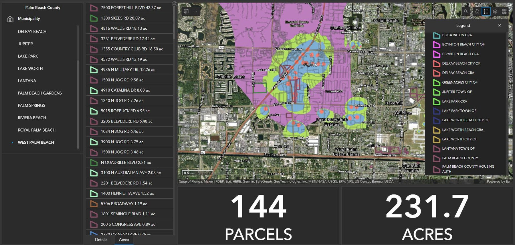
We presented results to stakeholders through web GIS visualizations, applications, and cartographic products, including web maps and dashboards. The dashboard cataloged selections and eliminations by geographic area, ownership, and supporting considerations, validating the datasets and assisting in the client’s decision-making.

Project Highlights:

  • Data and Mapping
  • Land Use Planning
  • Innovation 

Project Cost $25,000.00

Contact Our Team About Your Next Project.

At WGI, we creatively transform how our world is envisioned, designed, and experienced. Our expert team of professional engineers is ready to help.