WGI Icon_Green (1)
WGI Projects
Project Experience

Learn more about successful projects from some of our clients.

Plan Your Next Project!

Kick-start your next project with this quick step-by-step intake form.
About
WGI

WGI is a national design firm creatively transforming infrastructure and real estate through tech-driven services.

Our
Locations

You’ve seen our award-winning team, proven expertise, and industry authority. Now let’s make your next project a success.

Meet Our
Leadership Team

Our Executive Leadership Team and Practice Area Leaders bring decades of experience and client successes to your next project.

Our Practice Area Leadership

Our nationwide team of engineers, surveyors, planners, and architects offers
market-leading experience.

Firm Registrations

WGI holds nationwide registrations to perform engineering, surveying, architecture, and environmental science services.
WGI
Insights Blog

Our blog covers client interests like infrastructure, real estate, regulations, and smart, connected communities.

Whitepapers & Publications

Our whitepapers highlight our design experts' innovative insights and best practices for the AEC industry.

News &
Press Releases

Dedicated to your success, we invite you to subscribe to our newsletter for the latest news, case studies, and insights.

WGI
Media Room

Our passionate design professionals frequently share their expertise at webinars and virtual events.

Meridian Naval Air Station

Client:
United States Navy, Naval Facilities Engineering Command (NAVFAC)
Market:
Transportation
Location:
Meridian, MS

Project Details

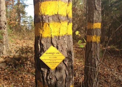
WGI performed installation boundary surveys and parcel acquisition surveys on approximately 8,084 acres of the Naval Air Station Meridian site, located in East Central Mississippi. Inaccuracies in existing information prompted the Navy to request cadastral surveying support to modernize numerous aspects of their geospatial data. In order to update boundary surveys and Real Estate Summary Maps (RESM) for many of their installations, WGI conducted deed research and performed surveys to establish the accurate legal boundaries per the recorded legal descriptions, identified Navy-owned acreage for each site, and provided corresponding accurate AutoCAD and Geographic Information System (GIS) mapping data. WGI acquired and reviewed descriptions of all Navy-owned parcels adjacent to the exterior boundary for each site and boundary survey monuments located at each site. Source documents included RESMs, legal documents, deeds, plats, and other maps. Thick underbrush and widespread tree canopies covered much of the boundary, requiring conventional survey equipment (i.e. total stations, machetes, and axes), while open area data was collected via global positioning system (GPS). Concurrent with the fieldwork, WGI surveyors transferred collected data to various WGI offices where experienced technicians manipulated the data for the highest quality deliverable. After a thorough Quality Assurance/Quality Control (QA/QC) review, WGI successfully delivered an accurate geo-rectified shape file for the Navy’s use in their GIS database.

Project at a Glance

  • Meridian Naval Air Station — image 1
  • Meridian Naval Air Station — image 2

Contact Our Team About Your Next Project.

At WGI, we creatively transform how our world is envisioned, designed, and experienced. Our expert team of professional engineers is ready to help.