
Download this publication as a PDF
Light Detection and Ranging systems – known universally today as lidar — were invented in the 1960s, with the technology growing in popularity during the 2000s in support of survey and mapping activities. Fixed-Wing Aerial Lidar (FWAL) was widely used for large-scale, large-area programs like the United States Geological Survey 3D Elevation program (USGS 3DEP). The speed of collection and swath coverage from FWAL makes it the ideal solution for mapping vast areas with minimal effort.
Terrestrial Mobile Lidar (TML) and Unmanned Aircraft Systems (UAS) lidar, along with Low-Altitude Mapping Platform (LAMP) photogrammetry, have long been engineer’s tools of choice – able to achieve high pulse densities, high accuracy, and great feature detection with those technologies. FWAL fell behind over time, no longer widely used for many engineering applications.
Yet over the past few years, innovations in lidar technologies gave the professional mapping community a new toolset for achieving a high-accuracy, high-density point cloud using FWAL. Specifically, the technology focused on in this paper is a dual-sensor aerial lidar system employed by WGI.
The Challenge
As a national provider of lidar data, WGI has an ever-expanding suite of laser scanning instruments — UAS, TML, Static Terrestrial, and FWAL solutions are routinely employed. When a project requires imagery and lidar data together, we examine relevant variables, including overall length, accessibility, safety, and accuracy, to determine the best platform for lidar data capturing.
For projects requiring aerial lidar and imagery, most of the costs are associated with data acquisition. Choosing the right acquisition tool (UAS, helicopter, or fixed-wing) can dramatically impact both cost and schedule. The fixed-wing approach has been the most cost-effective in acquiring aerial lidar and imagery data. The higher-flying altitudes and greater speeds provide wider right-of-way coverage and lower costs but historically, that came with a trade-off in spatial resolution and accuracy. For high-accuracy/high-resolution projects, the helicopter or UAS platforms have traditionally been the best choices. However, helicopters are expensive to operate and UAS, to stay cost-effective, are limited to smaller AOIs, and more airspace regulations. There are areas where we cannot fly a UAS with the current FAA regulations.
With our FWAL dual-sensor system, we can fly high and fast, but we maintain accuracies and point cloud densities that are normally found in helicopter or UAS solutions. This keeps the acquisition costs low without sacrificing data quality.
WGI’s Dual-Sensor FWAL Solution
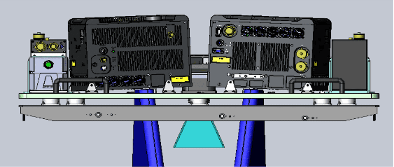
WGI was the world’s first company to purchase the G2 Dual-Sensor system from Teledyne Geospatial. The G2 configuration was designed to compete with the pulse density of less-proven lidar sensor technologies like Geiger and Single Photon, but with proven linear mode systems. The G2 Mount (shown below) provides a unique orientation of not one — but two — Teledyne Geospatial Galaxy T-2000s. The mount forces the sensors’ installation in a fore/aft facing direction with a +/- 5-degree pitch. This system configuration has far-reaching benefits for applications requiring higher-density and regular-scan patterns.
This design enables forward- and reverse-look angles at the target in the flight direction, across the entire swath. The benefits of this configuration include: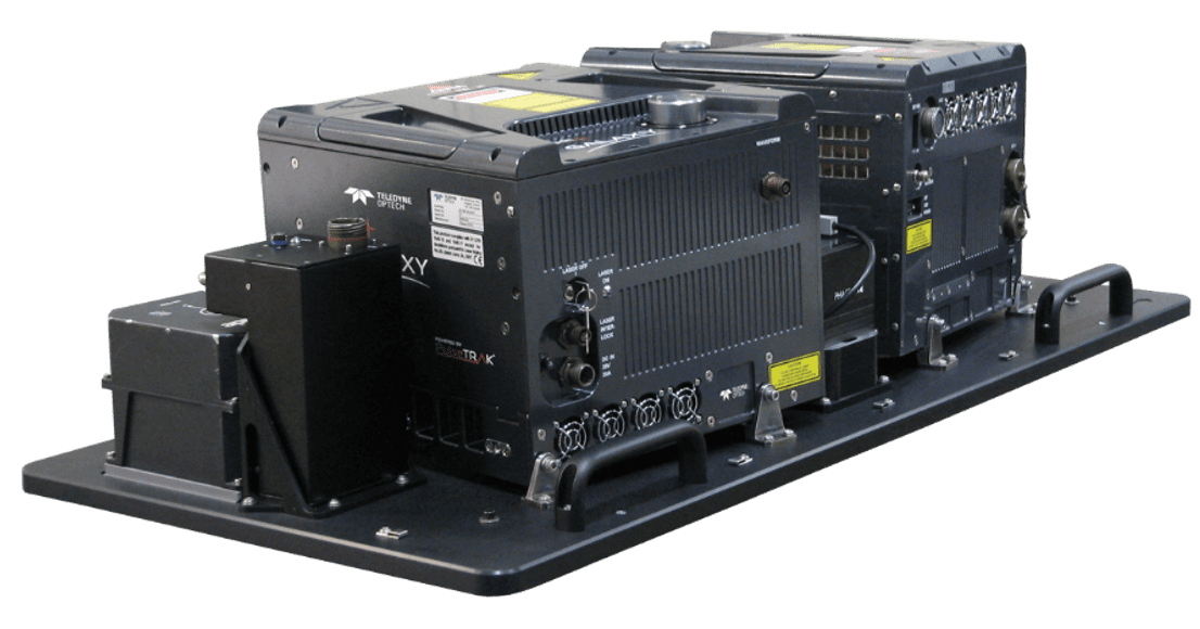
- Increases resolution of vertical surfaces/objects
- Minimizes ground “shadowing,” or occlusions, for improved ground coverage when compared to single-unit sensors
- Provides a “double pass” over the target to increase overall model density and vegetation penetration success
The dual-sensor sled also provides a slight rotation of +/- 10-degrees yaw. The benefits of this sensor rotation include:
- Creates a more regular point pattern on the ground
- Avoids scanline phasing for more consistent point density
- Provides different look angles to the terrain for additional target coverage
As a consultant various private engineering and state departments of transportation, we found that the dual sensor can be useful for many different applications.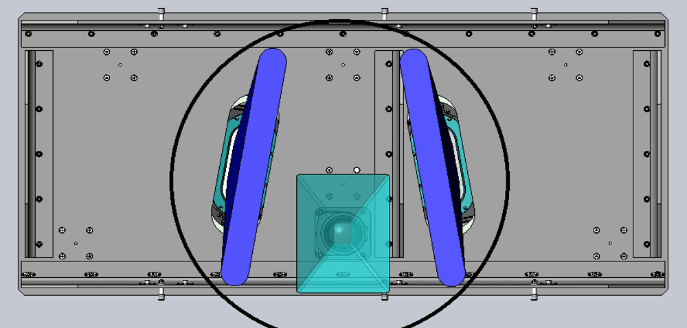
- Transportation infrastructure design
- Resurfacing projects and drainage analysis
- Roadway inventories
- As-built survey support
- Safety analysis projects
Flight Efficiencies (Cost Savings) Explained
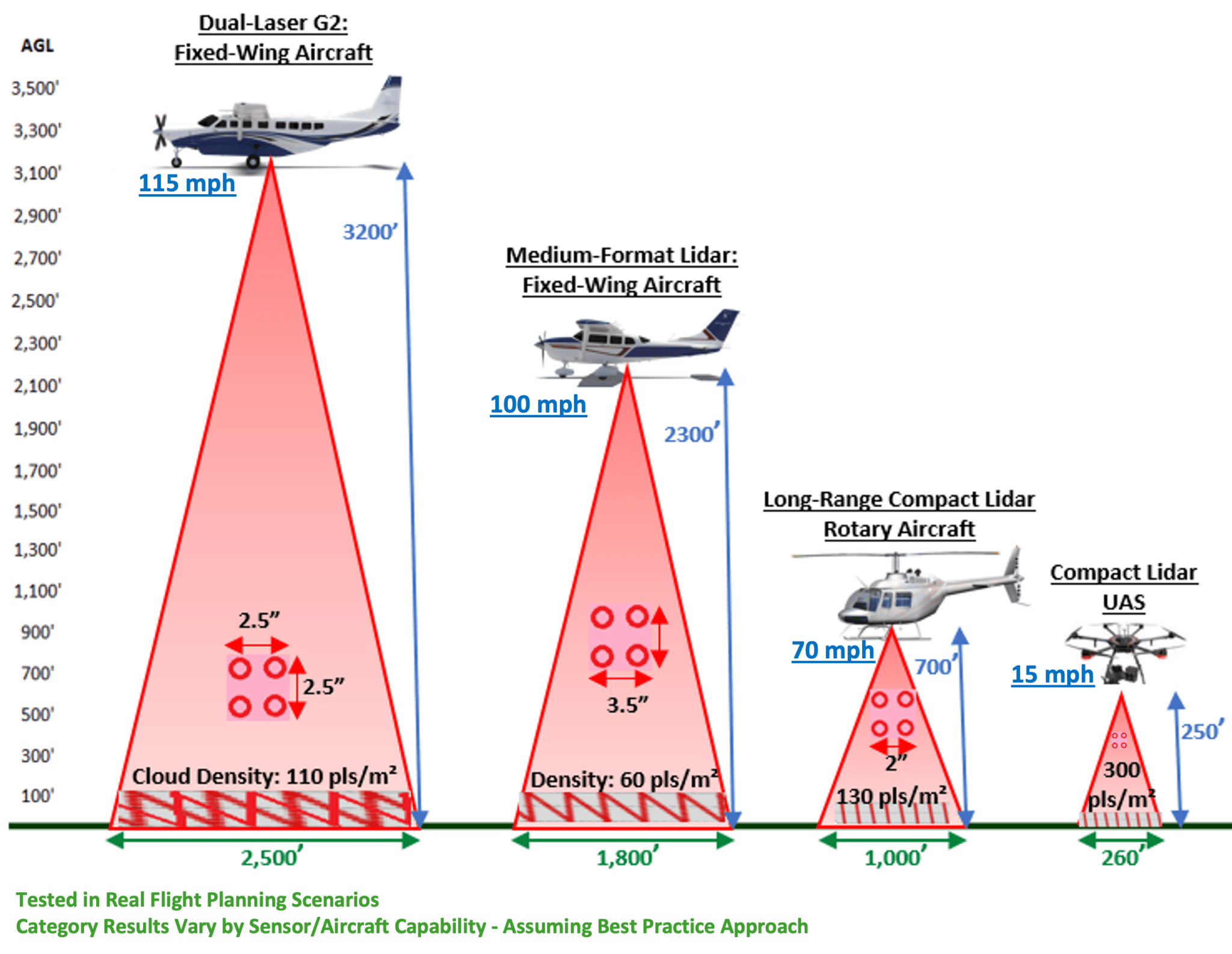
WGI routinely uses UAS, helicopters, single systems in a fixed-wing aircraft, and dual-system configurations in a fixed-wing aircraft for capturing lidar. We performed a conservative test-flight planning scenario, whereby the UAS solution is collecting at 250 ft Above Ground Level (ACL) at 15mph and achieving over 300 pulses per square meter. That solution’s limitation is we are only covering a 260-ft width with the lidar swath, so it would take many swaths to cover a larger project area of interest.
The helicopter flight plan is collecting at 700-ft AGL at 70mph and is achieving 130 pulses per square meter. The swath width is also wider than the UAS approach at 1,000 ft. This solution’s limitation is the cost point of operating a helicopter on an hourly basis, plus the challenge of mobilizing the helicopter either through a flight or on a flatbed 18-wheeler.
The single-system lidar configuration can be flown in smaller aircraft that are less expensive to operate than a helicopter. In this flight plan, we are collecting at 2,300-ft AGL at 100mph and achieving a density of 60 pulses per square meter. This is the most traditional FWAL combination operating in North America. This approach’s primary limitation is that we need in excess of 100 pulses per square meter to use the point cloud feature-extraction tools in TopoDOT that are so heavily needed by our design and transportation engineers.
Finally, the dual-system configuration collects at 3,200 ft at 115mph and achieves a density of 110 pulses per square meter. This approach is also yielding a width of 2,500 feet, making it ideal for capturing beyond the right-of-way for transportation applications. The dual-sensor allows us to match the density of a helicopter approach — but covering twice the area in significantly less time. The historical limitation of this approach and all other FWAL approaches is the expectation of accuracy compared to the UAS and helicopter solutions.
Depending on the parameters chosen, each of these systems can achieve greater results than what is highlighted in the graphic.
Case Study – I-565 (Accuracy)
Our first transportation test project flown with this system was a 4.3-mile stretch of I-565 just outside of Huntsville, AL. This project was tested with the cooperation of the Alabama Department of Transportation (ALDOT). The test area is covered with survey control that ALDOT routinely uses for the calibration of its fleet of TML sensors. Both WGI and ALDOT were curious about the accuracies that could be achieved with this new sensor configuration, supplementing TML as a replacement for helicopter configurations.
We planned the project with five overlapping flight lines, flown at 2,200 feet, with a lidar pulse rate of 2.8 million pulses per second. This entire flight plan was flown in 29 minutes. If WGI had a longer corridor project flown with similar specs, we could acquire around 80 line miles a day.
Using this flight approach, we collected 244 pulses per square meter, achieved a pulse spacing of 2.5 inches, and produced an RGB photo with a 1.7-in pixel resolution from the integrated camera system that operates simultaneously with the dual-lidar system.
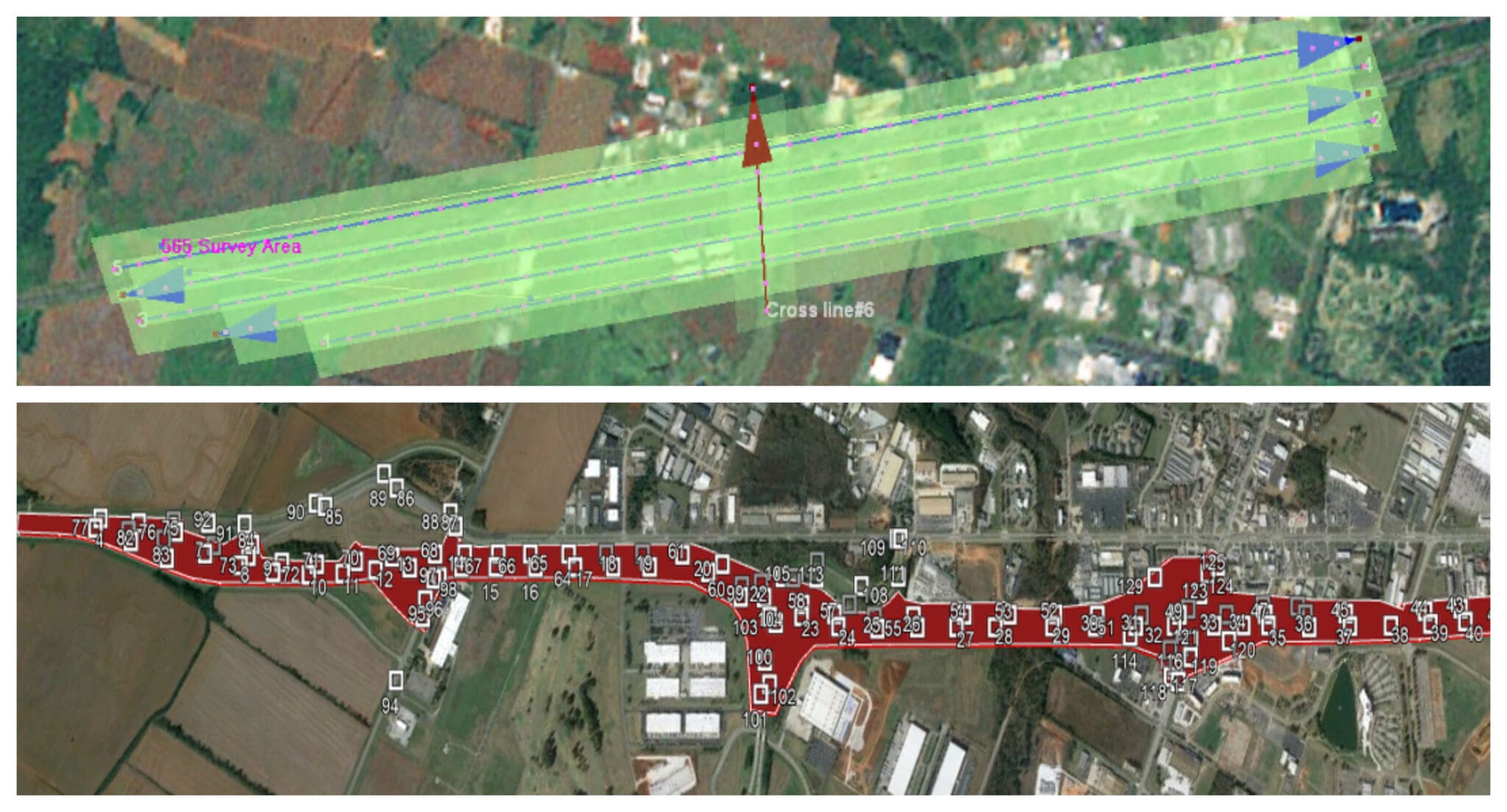
ALDOT provided WGI with photo-identifiable survey control collected as pairs every 500 ft along the corridor as well as outside the immediate right-of-way. There were 110 hard-surface points provided in total.
WGI utilized the 110 provided points to test the accuracy of this pilot project. Overall, we achieved an average Delta Z (DZ is the variance between a published value and the tested value) of +0.015-ft and an RMSEz of 0.062-ft.
WGI didn’t stop with that test.
We also elected to collect TML data of this same area to assess the results of a stand-alone TML solution compared to the control (and the airborne solution), and produce a merged point cloud from both technologies with the potential to provide our clients show-stopping details, coverage, and accuracies compared to anything else in the market. The results of those tests are shown in the table.
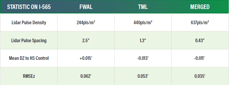
We expected our TML solution to outperform the FWAL solution in density, pulse spacing, and accuracy — and it did all of those things. What we did not expect is that through calibrating the two datasets together, we actually improved the accuracy of both products since each acted as another source of control when calibrated together. The results of the merged point cloud were astounding with 637 pulses per square meter, mean DZ to control at -0.011-ft, and a RMSEz of 0.035-ft.
Overall, the test project was a smashing success by proving that the dual sensor can replace a helicopter on these types of projects as well as supplement the TML and UAS collection for multipurpose projects.
Case Study – I-75 (Feature Extraction)
The second test project for this innovative solution was collected in Florida. We flew a five-mile stretch of I-75 that resulted in 406 pulses per square meter, a pulse spacing of 1.9-in and an RMSEz of just over 0.03-ft. The project collection took less than 45 minutes. These results mimic helicopter and UAS results with easier access than UAS and a significantly lower cost than a helicopter.
The data collection was not the overall deliverable for this project. We utilized TopoDOT to extract 59 feature codes from the high-density lidar point cloud (not from collection on imagery). Historically, the FWAL’s lower pulse densities did not allow us to utilize the most efficient data collection tools available in TopoDOT. Instead, we would rely on manual extraction (more labor hours) from a combination of the point cloud and the co-collected imagery. The data were collected using some of the automated feature templates available in the software, and the density allowed us to capture features that were previously only detectible in TML and UAS point clouds, like subsurface utility paint markings.
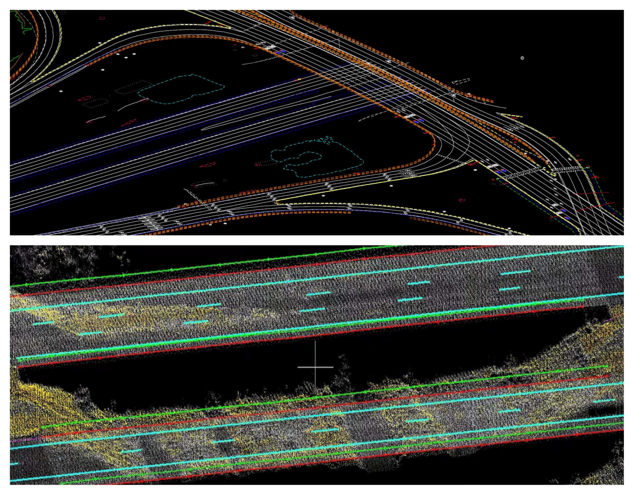
This project also shows off the ability to use this high-quality data as an alternative to TML and photogrammetry for resurfacing projects. The results are shown below.
The project performance metrics were remarkable. With a considerable reduction in fieldwork, the dual-sensor allows for a substantial decrease in staff-hour estimates as compared to TML. Under the right project site conditions, the dual aerial sensor permits a decrease in overall field efforts reflected in staff-hour estimates as compared to only using TML.
Survey Crew Safety – The Hidden Benefit of This Approach
WGI has a long-standing corporate commitment to safety. One of our three Core Values is Passion for People. The daily focus of our operational and executive leadership is caring for our associates and keeping them out of harm’s way.
Since the FWAL swaths are significantly wider than TML or UAS solutions, survey control placement can be optimized with safety in mind. The broader buffer widths and reduced need for photo-identifiable points permit control placement to be moved away from busy thoroughfares, increasing the safety of those in the field and in most cases, eliminating the need for flaggers.
This approach also reduces the necessary access to private property since there is significantly more area to choose control points from compared to our TML and UAS solutions.
In Conclusion
At WGI, we are creatively transforming how our world is envisioned, designed, and experienced. Our firm is committed to the continued investment and growth of the point cloud market — regardless of the collection platform used because it improves engineering design. We recognize that our forward-looking investment in this innovative FWAL platform provides our clients with a unique opportunity to always choose the best tool for each project whether it is FWAL, TML, UAS, or traditional survey.
Our experienced team of over 150 geospatial professionals is ready to discuss our innovative approaches for surveying and mapping with any of our federal, state, local, and private partners.