From Vision to Construction – The Villas at Creekside
WGI’s team of professional landscape architects recently had the privilege of bringing the vision of a multi-use oasis to life for a single-family rental community in New Braunfels, Texas
Learn from award-winning professionals — explore our whitepapers, blogs, and the latest industry updates.
Join our dynamic organization of engineers, land surveyors, landscape architects, environmental scientists, and architects!
Talk to a market leader today! We’ll answer any questions you have about our professional services.

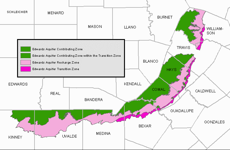
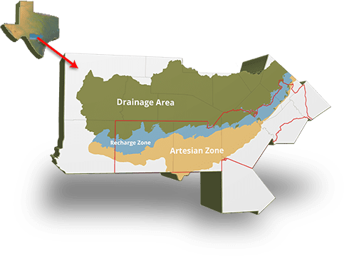
According to the Edwards Aquifer Authority, “basins in the drainage area of the Edwards Aquifer region collect rainfall and funnel it into fractures, faults, and fissures in the ground. These geologic conduits are direct pathways into the aquifer and, while allowing recharge to occur, contamination is also a possibility.” The water supply in South Texas is fed mainly by the Edwards Aquifer, which means protecting it’s means of recharging is especially important. Navigating the rules and regulations associated with the recharge zone can be tricky, so we’ve included a few tips here.
The first step to finding out if the recharge zone regulations affect your development is to discover if your development is, indeed, in the recharge zone. You can find the maps for your area here that outline exactly where the the contributing, recharge, and transition zones are in your location. After you determine that you are, in fact, in the recharge zone, you need to brace yourself. The recharge zone is one of the most restrictive areas in terms of regulations, so your proposed development may be significantly impacted.

If you are within the San Antonio Water System‘s service area (Most of Bexar County), you will want to review SAWS regulations within the Aquifer area. SAWS will require that a category status letter be filed. This letter will determine the allowed amount of impervious cover that is allowed on your site, and you can find a template for that letter here. Depending on the location and entitlement history of the site, the amount of impervious cover can vary widely from 15% to no restriction. In addition, SAWS may limit any development within the buffer areas adjacent to floodplain boundaries. Feel free to call Big Red Dog to help determine these limitations during your due diligence period or before beginning your project.
If you’re ready to proceed, it will be necessary to file a water pollution abatement plan (WPAP) with the Texas Commission of Environmental Quality (TCEQ). This document will be filed as a part of your Civil Construction documents and will be designed to mitigate any possible contaminants to the aquifer during and after your development. This “best management practice” will require 6 – 8 months of design, review and approval for your project. These ponds can be constructed above ground or in underground basins. You can find the necessary forms here on the Texas Commission for Environmental Quality’s site. The minimum fee for this form is $650, and the maximum is $10,000.
It may be necessary for your project to file an organized sewage collection system plan (SCS Plan). An SCS plan is required when sewer services serving more than one unit are installed over the aquifer, such as an apartment complex, single family development or large office park. These can be found here, and they are required before construction can begin.
It is important to discuss these items with your engineer prior to beginning the project in order to prepare necessary cost, land area, and project timelines for these concerns. With the right partner, your project can move smoothly through each of these issues to completion. Calling WGI to handle these facets of your project for you can save you time and money. Please feel free to contact us to discuss your project anytime.

WGI is a national design and professional services firm leading in technology-based solutions for the construction of public infrastructure and real estate development. At WGI, we’re providing Tomorrow’s Infrastructure Solutions Today.

WGI’s team of professional landscape architects recently had the privilege of bringing the vision of a multi-use oasis to life for a single-family rental community in New Braunfels, Texas

WGI moves up 37 spots on Engineering News-Record (ENR)’s 2020 Top 500 Design Firms List.

WGI is celebrating EWeek 2020 by honoring all of our dedicated engineers, and engineers around the world that have made a positive contribution to our profession.

On this episode of WGI Unleashed, we get to know Megan Amitrano, a Graduate Engineer from our San Antonio, TX office.

Before embarking on a development project in San Antonio, Texas, here are ten factors to consider to make sure your development project is a success.

WGI’s team of professionals provided civil engineering services for the second phase of the 13.5-mile Waterloo Greenway in downtown Austin, TX
You’ve been searching for a place like WGI. We look forward to meeting you soon.
Sign up to receive emails to hear our latest news and achievements in our monthly newsletter.
Enter your zip code, and we’ll personalize your experience with local projects, office locations, team members, and more.
WGI supports its associates with meaningful opportunities for growth, strong benefits and perks, while we work collaboratively with clients and co-consultants to shape and improve communities.


WGI is a dynamic organization with opportunities nationwide for engineers, land surveyors, landscape architects, environmental scientists, and architects.