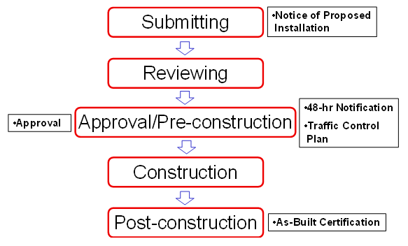
Out with old and in with the new. TxDOT no longer accepts paper, or PDF, utility permit forms. For new projects, you must use TxDOT’s Utility Installation Review System, or UIR for short. The new system does have a bit of a learning curve and hopefully this blog will save you a few headaches. To make this process as painless as possible, here are a few tips and tricks:
- Only use Internet Explorer as your internet browser when accessing the TXDOT UIR system. UIR is not browser agnostic.
- Go to “Tools” in the browser and select the “Compatibility Mode” and add the TXDOT site. Why do I have to do this? I don’t know, just do it.
- Go to “Tools” in the browser and turn the “Pop-up Blocker” Off.
- Always click on “Save and Continue” at the bottom of each step/page of the permit request form.
- Only use the TXDOT UIR system “Back” button. Do not use your browser’s back button!
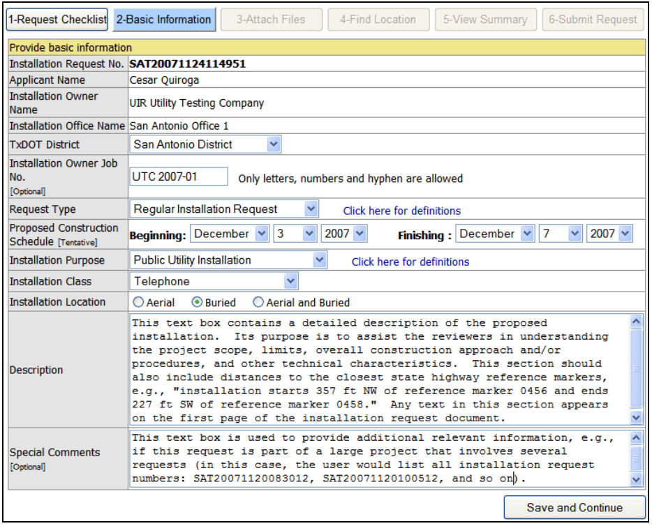
- On Step 2, provide a description of the work to be performed, i.e., water main or wastewater main, whether or not any of the work will be done within the TXDOT ROW, whether the construction method will be jack and bored, or, open trench excavation, or, a combination of the two.
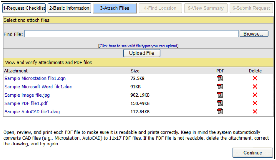
- On Step 3 you will upload files of the projects signed and sealed cover sheet, civil engineering plans and detail sheets including the TXDOT traffic control plans and TXDOT traffic control details. TXDOT only allows a maximum of five (5) files and a total of five (5) megabytes. You can scan multiple plan sheets into one file and upload them that way.
- When you get to Step 4 of the permit click on the “Show all Content” that will pop-up at the bottom of your screen for the map to display. Place your cursor over the map area and it should generate. Sometimes the entire State of Texas map will generate. Zoom in to the area where your project is located. If the map will not generate after zooming in, click on “Switch Basemap” and the map should generate. You may have to click on Zoom and the Switch Basemap a few times to get zoomed into the location you need.Once you have zoomed into your project’s location, place the cursor over the area where the work will be conducted and click on that spot. The map will display an AUS number at that location. That is your TXDOT Permit Number. Check the District and Route No. in the table at the bottom of the map. Sometimes they are incorrect. Most of Austin Water’s work is within the Austin District but sometimes it is in the Georgetown District. It is easier to see whether or not the Route No. is correct. For instance, you may have a project on MOPAC, Route No. SL0001, but instead the table displays SL0360, which is Loop 360/Capital of Texas Hwy. To correct the Route No., click on the star next to the AUS number on the map and slightly drag it along the roadway until the correct Route No. appears in the table. And as always, be sure click on “Save and Continue” at the bottom right of the permit page.
- Step 5 is a review of steps 2 and 3 combined.
Once you have completed all these steps, contact the Jurisdiction that owns the utilities. For example, if you are working in Austin, this will be your Austin Water reviewer. The owner of the utilities will submit the application to TxDOT. Additionally, comments from TxDOT will be e-mailed to the owner, so make sure to follow up in two weeks on the status.