

Texas Medical Center Parking Garage Problems
Texas Medical Center made $78M from parking last year. Why haven’t its busiest garages been upgraded in years?
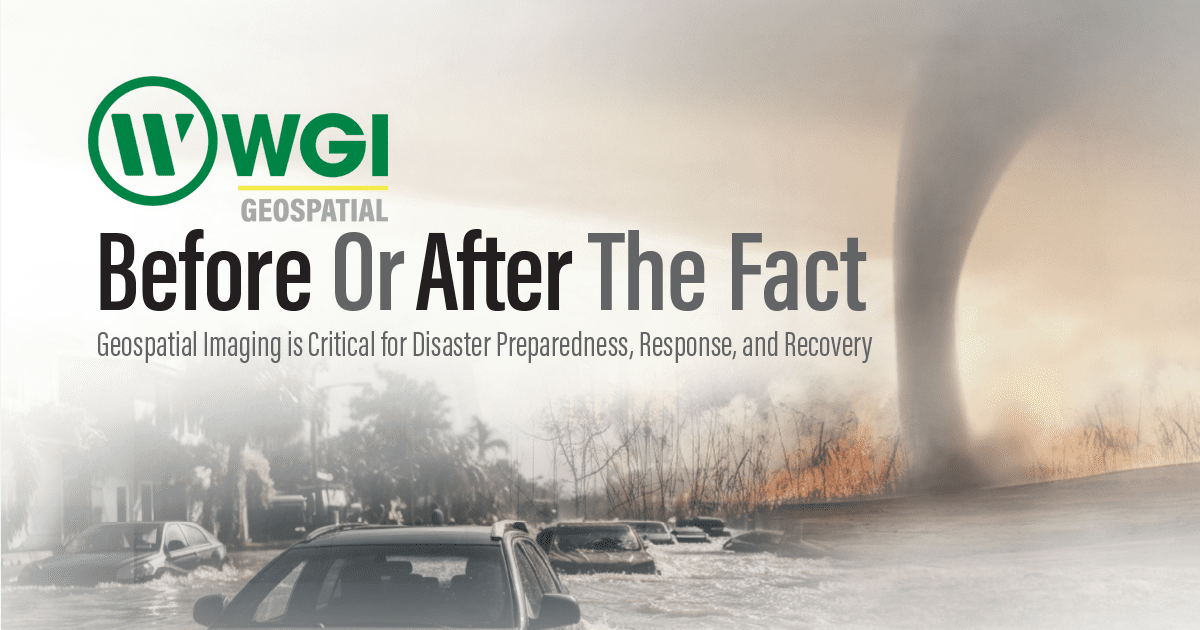
The recent widespread tornado outbreak throughout the central and eastern United States reminds us that wildfires, floods, earthquakes, tornados, and hurricanes can happen virtually any time. Depending on where they occur, it can disfigure a rurality, city, riverfront, or coastline. They can also destabilize critical infrastructure.
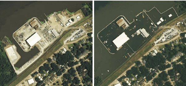
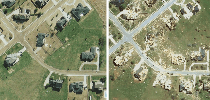
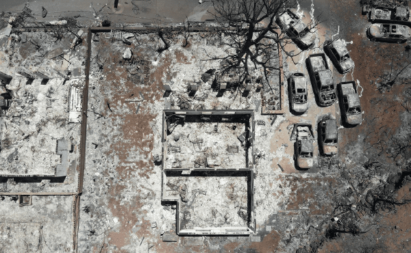
When disaster strikes, it’s vital to know what the affected area looked like before and after the event. This prior-and-post intelligence, instrumental in the process of change detection, can then be used for situational analysis, resource allocation, route optimization, risk assessment, communications, public outreach, and problem solving in a short amount of time, aiding first responders as they wade into dangerous, frequently contaminated areas.
Geospatial technology is key to obtaining this invaluable information – a digital twin of landscapes, cityscapes, buildings, and critical infrastructure. At WGI, with its 150-person team of geospatial experts, collecting this type of data utilizing a full suite of technologies and methods is an established service available to both the public and private sectors.
For indoor spaces, the firm uses backpack lidar. For outdoor settings, static lidar is the method of choice when capturing images of bridges and intersections. For mapping roadways at highway speeds, mobile lidar is essential. While not based on laser imaging, WGI uses proprietary technology for real-time flood forecasting – Floodwise™ and Stormwise™ – to track and predict flooding of streets and subdivisions.
Hurricane season is front and center, beginning on June 1st every year. According to the National Oceanic and Atmospheric Administration (NOAA), there were 20 named storms out of the Atlantic basin in 2023. WGI has plenty of experience in hurricane disaster response, too.
Perhaps the most-used service WGI offers for disaster response is its airborne lidar and imagery. Using a fleet of pre-equipped manned and unmanned aircraft, the firm can quickly arrive at and assess vast areas of land anywhere in North America.
These highlights represent an emergency response. However, a proactive approach is advisable for local and state governments and private entities looking to enhance their resilience. Why wait until disaster hits to figure out how to respond and recover?
While there are undoubtedly plenty of public entities not tied into WGI’s geospatial services, there are many that are. For government entities, we have nearly 100 continuing service agreements at the state and federal levels that can serve clients across the United States. For most government agencies, geospatial services through WGI are likely a phone call or email away. For such entities, disaster response is not the only consideration. Sea-level rise, deforestation, and fault-line detection are key areas where geospatial technology is optimal for risk assessment. Local projects like dikes, dams, bridges, and utility relocation can benefit from the speed and precision of laser imaging.
Enrollment is easy for private entities not contracted with WGI’s geospatial team. Just contact the firm to let us develop a multiyear contract that can serve as an insurance policy, with WGI secured on a retainer basis. Or the entity could contract for specific, proactive services so that the data sets are on hand when needed.
One thing that all catastrophes have in common is the cleanup. Depending on the size of the event, the bill could add up to millions in local, state, and federal dollars. Just consider the massive ice storm of 2009 affecting nearly a dozen states, particularly Arkansas and Kentucky. The storm created mountains of vegetal waste that took weeks to clear. In such circumstances, precision lidar data can measure the amount of debris, thus limiting the potential for fraud for budget-minded state and local governments.
While weather systems like the one that created the ice storm don’t often happen, they do come around. In addition to debris removal, a critical problem to confront in the aftermath is that of utilities. During the ice storm and its effect on north Arkansas, thousands of households throughout the Ozarks were without power for weeks. People suffered. Fast forward from 2009 to now, and the conclusion is evident – more information and resources are fundamental to a successful recovery.
Without advanced information, the fallback is doing things the way they’ve always been — and that’s a problem. Limited resources, including personnel, equipment, and supplies, typically constrain traditional disaster response methods. Inadequate pre-positioning of resources and logistical challenges
in transporting supplies to affected areas can hamper response efforts and prolong recovery times. Many communities and organizations lack comprehensive disaster-preparedness plans and training programs to respond effectively to emergencies.
The largest wildfire in Texas history raged in the panhandle in February, consuming millions of acres along with livestock, homes, and power lines. This spring, tornadoes tore through Oklahoma, causing widespread damage and multiple fatalities. In March, a cargo ship rammed into the Francis Scott Key Bridge in Baltimore, causing it to collapse into the channel. And last year, a flash fire destroyed Lahaina, Hawaii, and caused over 100 fatalities. Terrible accidents happen, as do large-scale natural disasters. It’s not a matter of if but of when. Are you prepared? Better yet, do you want to be prepared before or after the disaster happens?
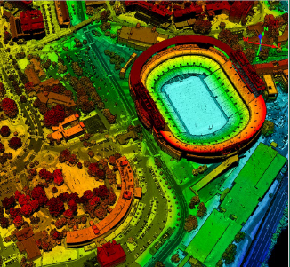
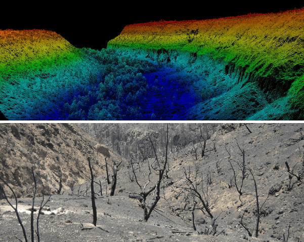
WGI has extensive experience flying, processing, and deriving a wide range of geospatial products using the most precise topographic airborne lidar sensors available. Three Galaxy T2000 systems are integrated with PhaseOne iXM-RS100F RGB cameras and staged nationwide for rapid deployment. This service is extremely diverse as the sensors can be flown to produce high-resolution, engineering-level data or cover hundreds of square miles in an hour for wide area elevation mapping. Co-registered lidar and imagery offer the horizontal accuracy and resolution of the imagery, combined with the vertical accuracy and canopy penetration of topographic lidar. WGI is also the first adopter of the G2 Sensor System, a dual-laser and semi-oblique lidar platform that can fire an unprecedented 4 million effective laser pulses per second. With an even distribution of points and an improved capture of above-ground features, the G2 can produce 3D lidar point clouds at the resolution we have come to expect from less-efficient alternatives.

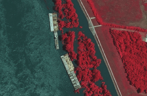
WGI provides high-resolution airborne imagery services using advanced imaging technologies and multiple manned and unmanned platforms. WGI was the first firm in North America to take delivery of the PhaseOne PAS280 multi-spectral large-format imaging system. The PAS280 delivers crisp, 4-band imagery over 20,000 pixels wide in each frame. With a high dynamic range and altitude flexibility in a fixed-wing manned aircraft, WGI can efficiently deliver high-resolution orthophotography even when conditions or airspace restrictions are less than ideal. In addition to our large-format camera systems, we also have a fleet of UAS (Unmanned Aerial Systems) perfect for small areas, quick response, construction monitoring, or debris removal monitoring.
WGI’s mobile mapping fleet is mountable on a diverse range of vehicle platforms for integrated, multi-sensor solutions and mapping and engineering grades. Our mobile mapping lidar systems include the Riegl VMX-2HA, Riegl VMY-2, and Leica Pegasus 2. These are configurable with the Mosaic X and Ladybug 360-degree imagery and the ImpulseRadar Raptor GPR. At highway speeds, these sensors collect dense and highly accurate 3D data capable of identifying key features and assets — both above and below the ground. Combined with advanced software solutions and WGI’s thought leadership, we offer precise asset management or geolocation of telecom and electrical distribution components, relevant vegetation encroachment, pavement conditions, road features, and a detailed survey of critical infrastructure. Because the data is collected at highway speeds, the associated field effort is dramatically reduced, providing significant time savings on schedule-critical assignments. WGI is currently using this cutting-edge service for multiple DOTs and several municipalities. In addition, the WGI Geospatial staff utilizes advanced mobile lidar capabilities to acquire elevation data in flood inundation zones. This data is processed and used to produce finished floor elevations (FFE) for all primary structures for flood planning and mitigation purposes.
WGI’s high-tech geospatial backpack lidar makes it easy for a single operative to scan remote locations – making mobile surveying safe, fast, and cost effective. This wearable lidar capture platform allows our professionals to conduct detailed surveys and photo documentation of indoor, outdoor, and underground spaces by simply walking the project. The Pegasus Backpack is ideal for various applications, including site surveys, building information modeling (BIM), industrial asset-management data collection, building safety and security analysis, and natural disaster response. It is portable and checked as regular luggage on a flight, bringing instantaneous deployment capability to WGI clients nationwide.
WGI’s static lidar scanners provide high-grade solutions when accuracy matters, or when quickly assessing tight spaces impacts response times. Capable of collecting one million data points per second, 3D high-definition static laser scanning provides precision and accuracy with a range of up to 1,000 feet. Static laser scanning captures everything visible within centimeter accuracy during a single deployment, limiting the need to return to the site for supplemental work. This type of data collection significantly increases work safety specifically when roadway or industrial data is needed. The P-Series scanner provides long-range performance typically used outdoors for buildings, bridges, or intersections, while the BLK360’s sleek design is best suited for indoors and tight spaces such as small rooms, crowded piping, or drop-ceiling space. This captured data, called a point cloud, is processed into CAD or GIS deliverables for final modeling, architectural, or engineering designs.
WGI’s hydrographic survey vessel fleet takes our geospatial capabilities to the water. WGI’s highly trained professionals utilize state-of-the-art technology to provide our clients with quality hydrographic and marine geophysical data. Our fleet of survey vessels, equipment, and resources allows WGI to collect, process, and deliver accurate bathymetric datasets safely and efficiently. WGI’s processes and methodology are designed to meet or exceed the U.S. Army Corps of Engineers, U.S. Geodetic Survey, and International Hydrographic Association industry standards. The Z-Boat is ideally suited to near-shore and inland hydrographic survey assignments including beach renourishment, canal analysis and restoration, coastal estuary evaluation, inland waterway surveys, and structure collapses. WGI can ship it via air freight; in just hours, it can be regionally or nationally deployed, supporting disaster response and other schedule-critical wet survey assignments.
WGI owns and operates cutting-edge air/vacuum excavation and designating vehicles equipped with the latest geophysical prospecting/locating tools, and ground-penetrating radar systems, to produce accurate record data. Armed with this information, our SUE experts provide critical project data supporting design projects, minimizing utility impacts, ensuring safe worksites, and preventing damage to utilities while controlling costs and schedules. Safety is foremost to all stakeholders; saving time and money is essential for all successful projects. Our specialized SUE services allow your project to proceed safely, efficiently, and with the least disruption.
Floodwise™ and Stormwise™ technology work together to track real-time rainfall and predict rainfall amounts 10 days into the future – an excellent system for predicting flooding of streets and houses.
For more information about this study or to have a conversation with one of our experts, please contact us today.
WGI is a national design and professional services firm leading in technology-based solutions for the construction of public infrastructure and real estate development. At WGI, we’re providing Tomorrow’s Infrastructure Solutions Today.
Texas Medical Center made $78M from parking last year. Why haven’t its busiest garages been upgraded in years?
WGI, in collaboration with Leo A Daly, is honored to receive the 2024 AIA Palm Beach Merit Award of Excellence for our role in designing the lush, wellness-focused outdoor spaces of Toby & Leon Cooperman Sinai Residences’ new expansion. Discover how our landscape design enhances luxury senior living with resort-style amenities and inviting social spaces.
WGI proudly attended the 2024 CUTR Transportation Achievement Awards, celebrating impactful contributions and emerging leaders in Florida’s transportation sector. Dive in to learn more on how we’re continuing to propel the industry forward!

Join WGI SATX at the 10th Annual UTSA Engineering BBQ Cook-Off, where we served up smoky flavors, community connections, and a little STEM inspiration!

Discover the journey of minority women in civil engineering as they overcome challenges, redefine leadership, and build a more inclusive industry.
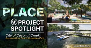
Discover how WGI is partnering with the City of Coconut Creek to reimagine Donaldson Park and Sunshine Drive Park with new recreational amenities, scenic trails, and enhanced landscapes—bringing innovative, sustainable design to the heart of the community.
