Accuracy deficiencies contained in recent revisions to FEMA flood insurance rate maps may have far reaching insurance impacts to residents of the Village of Wellington. In an attempt to mitigate undue flood insurance expenses to Village of Wellington residents resulting from erroneous flood classification, WGI was issued a Work Order under a continuing contract with the village to provide the certified elevation data needed to enhance the accuracy of FEMA flood maps within the Village limits. In total, the study area for the project included approximately 48 square miles and encompassed the developed limits of the Village.
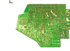
WGI utilized aerial Light Detection and Ranging (LiDAR) to acquire elevation data on a 2-foot grid throughout the project area. Control for the project was established using static GPS methods, which included precise elevation determination in accordance with National Geodetic Survey guidelines. Two hundred ground classification elevation positions were also collected using conventional survey methods, and more than 300 geo-referenced ground cover photos were obtained.
The final deliverables included a certified FEMA classified LiDAR dataset for the study area, which includes the typical FEMA ground cover classifications (canopy, grass/shrubs, bare earth, water bodies, pavement, etc.). Index contours at .5-foot and digital elevation models (DEM) were also developed from the LiDAR dataset and delivered in both AutoCAD and ArcGIS formats. FEMA-compliant GIS metadata was also developed and submitted to the Village.
.png?width=185&height=175&name=WGI%20Icon_Green%20(1).png)


















 PORT ST. LUCIE
%20copy%203.png?width=640&height=420&name=MicrosoftTeams-image%20(2)%20copy%203.png)