Innovation From Within: WGI’s Associates Pitch Ideas for the Future
WGI associates participated in an internal contest to pitch innovative ideas to improve the company, their work product, and the built environment.
Learn from award-winning professionals — explore our whitepapers, blogs, and the latest industry updates.
Join our dynamic organization of engineers, land surveyors, landscape architects, environmental scientists, and architects!
Talk to a market leader today! We’ll answer any questions you have about our professional services.

The 2024 Engineering Excellence Awards Gala (EEA), hosted by The American Council of Engineering Companies (ACEC), proved to be a powerful and inspirational event yet again this year. Celebrating the outstanding achievements of engineering firms worldwide and the remarkable projects they have spearheaded, this annual gala is a testament to the innovative spirit and dedication of the engineering community.
Each year, distinguished judges from various industry sectors meticulously evaluate projects based on criteria such as uniqueness, innovative applications, future value to the engineering profession, and complexity. As it has become tradition, the prestigious event took place in the heart of Washington, D.C., drawing top engineering talents from across the globe.
Among the many celebrated firms that were awarded hardware at this prestigious event, WGI stood out as a 2024 National Recognition Award Winner, honored for our significant contributions to the groundbreaking Brightline High-Speed Rail project. This accolade marks the third major award for the project, following the MAPPS Geospatial Excellence Award and the ACEC-Florida Engineering Excellence Award secured earlier in the year.
Florida, as with much of the nation, is currently experiencing a transportation revolution, with the Brightline High-Speed Railroad acting as the de facto ‘locomotive.’ This state-of-the-art rail system, connecting Miami to Orlando with plans for future development to Tampa, offers an alternative to time-consuming, expensive, and increasingly dangerous vehicle travel while promoting sustainability.
HSR Constructors spearheaded the project, with WGI providing critical geospatial and land surveying services to support the initiative. The construction of the dual-track railroad within the historic Florida East Coast Railway right of way, covering over 130 miles, demanded precise surveying and geospatial services over three years to ensure its success.
WGI’s crucial role involved construction layout, surveying, and asset information collection, supporting the enhancement of the existing railroad into a dual-track high-speed corridor, including improvements to 155 at-grade road crossings and 28 bridges. Each bridge had unique measurement and monitoring technologies, ensuring stringent accuracy criteria for track geometry and rail gauge. The construction of the bridges, particularly the longest at 1,650 feet over the Sebastian River, required long-term monitoring to ensure structural integrity for high-speed train travel.
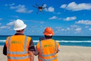
WGI employed cutting-edge technologies that verified existing conditions, assessed as-built structures, and managed potential conflicts during construction to achieve the highest level of precision and accuracy. One of the innovations developed during this project, the Work Order Tracking System (WOTS), helped our team of experts effectively coordinate multiple survey crews within an active railroad right of way. To ensure safety and efficiency, WGI implemented a revolutionary automated monitoring system using robotic stations with cellular connections for continuous measurements.
The innovations from the Brightline project are now being applied in various engineering projects across the nation, revolutionizing geospatial engineering and paving the way for future advancements.
To get a behind-the-scenes look at the award-winning ingenuity and unwavering dedication of WGI’s geospatial team on this revolutionary project!
Contact WGI’s team today, and let’s discuss the added value our team of experienced professionals can offer in ensuring that your next project is an award winner!

WGI is a national design and professional services firm leading in technology-based solutions for the construction of public infrastructure and real estate development. At WGI, we’re providing Tomorrow’s Infrastructure Solutions Today.

WGI associates participated in an internal contest to pitch innovative ideas to improve the company, their work product, and the built environment.

WGI is adding new versatility to our lidar capabilities with the introduction of lidar USA’s “Snoopy” system.

Learn how to gain reliable underground utility location information and reduce costly delays due to conflicts or damages.

Jim Sullivan has been accepted into Leadership Palm Beach County Engage Program where he is one of 55 professionals selected for the esteemed program.

Nick will support WGI in the development and implementation of technology-enabled strategies for innovation, sustainability, growth, and leverage opportunities for digital transformation.

Welcome back to WGI Unleashed! In this episode, we have a conversation with Matt Floyd, a Project Surveyor with our Geospatial Team in West Palm Beach, Florida.
You’ve been searching for a place like WGI. We look forward to meeting you soon.
Sign up to receive emails to hear our latest news and achievements in our monthly newsletter.
Enter your zip code, and we’ll personalize your experience with local projects, office locations, team members, and more.
WGI supports its associates with meaningful opportunities for growth, strong benefits and perks, while we work collaboratively with clients and co-consultants to shape and improve communities.


WGI is a dynamic organization with opportunities nationwide for engineers, land surveyors, landscape architects, environmental scientists, and architects.